| Other Attraction Of Jaldapara |
|---|
-
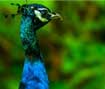
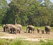 Jaldapara National Park
is a national park situated at the foothills of Eastern Himalayas in Alipurduar Sub-Division of Jalpaiguri district in West Bengal and on the bank of river Torsa. Jaldapara is situated at an altitude of 61 m. and is spread across 216.51 km2 (83.59 sq mi) of vast grassland with patches of riverine forests. It was declared a sanctuary in 1941 for protection of the great variety flora and fauna. Today, it has the largest population of Indian one horned rhinoceros in the state, an animal threatened with extinction, and is a Habitat management area (Category IV).
The nearby Chilapata Forests is a elephant corridor between Jaldapara and the Buxa Tiger
Reserve Also close by is the Gorumara National Park, known for its population of Indian Rhinoceros.
-
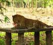 South Khairbari nature park
About 11 km. from Jaldapara, this Tourist Centre is actually a Leopard Rehabilition Centre and Nature Park. River Boori Torsa is flowing through the forest. It is interesting to travel in the leopards' empire on battery-driven cars. Recently, the Royal Bengal Tigers released from the Circus Parties have been rehabilitated here.
Going from Madarihat towards Birpara, a road in the left side goes to Khairbari. This is a good way. Sometimes herd of elephants appear. There is a Watch Tower on the river bank wherefrom you may see the leopards going this way and that, green waves on the sides of the river, scene of
boating. There is a wooden bridge over the river. Crossing over the bridge there is the Nature Park. There are many arrangement for children's enjoyment in the Park. It is a picnic spot also.
-
 Kunja Nagar Eco Park
Nearly 7km. from Falakata, touching Jaldapara Sanctuary, lies this Eco-Tourism Park. Here you can see leopard, deer, gharial and rose-ringed parakeet. If luck favours, you may see rhino, deer or elephant during boating.
Wild animals are not found always, but sitting on the Watch Tower you will feel nature as your own. There is arrangement for picnic. So day time remains lively. The evenings are beautiful. If you go up the Watch Tower in a moon-lit night, you will not like to come down. There is electric wire fencing for safety from elephant attacks. For night stay there are Forest Bungalow and Tower House.
-
-banner17.jpg) Phuntsholing (Bhutan)
Phuntsholing (Bhutan)
Phuentsholing is the point of entry for travelers arriving by bus from Kolkata and Siliguri and the town functions primarily as a place where Bhutanese and Indians do business. The architecture is modern, and there is no dzong, famous monastery or in fact anything of particular interest to tourists. However, like all of Bhutan, it does offer a clean, pleasant and safe environment in which to go about your business. NB: Until 2005, it was possible for overseas visitors to enter the town without a Bhutanese visa. Except for Indian nationals, this is no longer possible. Indians are denied entry beyond the checkpost in the absence of a permit.
-
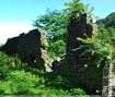
 Chilapata Nal Rajar Garh
The chief attraction at Chilapata is the "Nalraja Garh". There exist the ruins of an old fort in the dense forests at Chilapata on the east bank of the Torsa river a few miles south of the Indo-Bhutan border. It is popularly called "Nal Rajar Garh". The Britishers called it "the Mendabari ruins". After excavations at this place undertaken by the archaeological department have shown that these brick constructions belonged to the "Gupta Age". It was identified to be one of the frontier fortifications of the region then known as " Pundrabardhan Bhukti".
-
 Buxa Fort
is located at an altitude of 867 metres (2,844 ft) in the Buxa Tiger Reserve, Jalpaiguri district, West Bengal. It is located 30 kilometres (19 mi) from Alipurduar, the nearest town. According to Sailen Debnath, Buxa is one of the earliest forts in Eastern India. He suggests that the fort might have been first built either by the Tibetan Occupation Forces in the middle or in the second half of the seventh century or by Sangaldwip, the first ruler of Kamatapur. In subsequent times, the Koch kings had taken possession of the fort before it was seized by the Bhutanese in the second half of the eighteenth century. The Bhutan King used the fort to protect the portion of
famous Silk Route connecting Tibet with India, via Bhutan. Still later during unrest in Occupation of Tibet, hundreds of refugees arrived at the place and used the then abandoned fort as refuge.
-
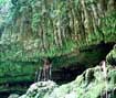
 Jayanti
is a small forest village within Buxa Tiger Reserve in Jalpaiguri district of West Bengal, India. It is located along the Jayanti River, forming a natural border with the Bhutan hills. It is popular with hikers for its beautiful views of the surrounding landscape and wild fountains. The 13 km trek from Buxaduar to Jayanti is especially popular, passing through the dense forest of the Buxa Tiger Reserve. Jayanti also features a stalactite cave known as the Mahakal cave.
-
 Totopara
is a small village on a hillock located 89° 20'E and 26° 50'N in the Jalpaiguri district of West Bengal, India.
This village is home to the unique Toto tribe that is one of a kind in the world. The village is about 22 km from Madarihat, which is the entry point of the famous Jaldapara National Park.
Administratively, this village falls under the Madarihat police station. It is bounded by the foothills of Bhutan to the north, Torsa River to the east, and Titi river and the Titi reserve forest on the south-west separated by the Hauri river.
The nearest village is Ballalguri, which is about 5 km to the south of Totopara. There is a single lane motorable road leading to this village from the National Highway 31 through Hantapara. The area of the village is about 8.08 km.
In 1990 a primary school was opened to cater to the children of the village and since 1995, a high school with hostel facility was also opened. There is one primary health centre in the village
-
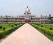 Cooch Behar Rajbari
is the district headquarters and the largest city of Cooch Behar District in the Indian state of West Bengal. It is situated in the foothills of the Eastern Himalayas and located at 26°22′N 89°29′E. Cooch Behar is the only planned town in North Bengal region with remnants of royal heritage. One of the main tourist destinations in West Bengal, the town is well known for the Cooch Behar Palace and Madan Mohan Bari temple and has been declared a heritage town. It is also well known for being the maternal home of Maharani Gayatri Devi. During the British Raj, the town of Cooch Behar was the seat of the princely state of Koch Bihar, ruled by the Koch dynasty.
After 20 August 1949, Cooch Behar District was transformed from a princely state to its present status, with the town of Cooch Behar as its headquarters.]
-
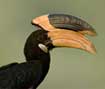
 Garumara National Park
Located at a distance of 80 kms from Jaldapara, Gorumara National Park is situated on the bank of rivers Murti and Raidak in the terai region of Dooars on the foothills of Eastern Himalayas. Gorumara is famous for its Asiatic one horned Rhino, Asian Elephants, Bisons, Peacocks. This was a reserve forest since 1895. In the year 1949, the park was declared as Wildlife Sanctuary for its breeding population of one horned Indian Rhinoceros. On January 31, 1994, it was declared as a National Park. The 80 sq. km area of the Gorumara National Park is famous for its rich variety of flora & fauna. The park is located in the Malbazar subdivision of Jalpaiguri district, in the state of West Bengal in India. The Murti, Jaldhaka, and Indong rivers flow through the Park on the foothills of the Himalayan ranges in the North making the whole region picturesque. The park offers breathtaking landscape with its rivers and mountain ranges. Lataguri a small town adjacent to the park is the entry point.
-
 The Buxa Tiger Reserve
It was established in the year of 1982-83 to save the most important species of North Bengal The Royal Bengal Tiger. The park is located at the north eastern corner of Dooars plains of North Bengal bordering Bhutan and Assam. The core area of 315sq.kms around the Buxa Duar Fort was declared a National Park in January 1992.
-
 Bhutan Ghat
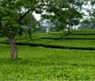
It is 85 kms from Madarihat, the road passes through beautiful forest and tea gardens. and a picnic spot.
Copyright © Jaldapara Inn. All rights reserved.